San Lorenzo al mare

Erkundung der erste Stadt auf dem Radweg


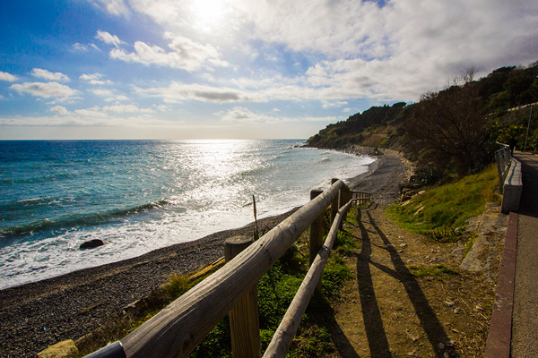
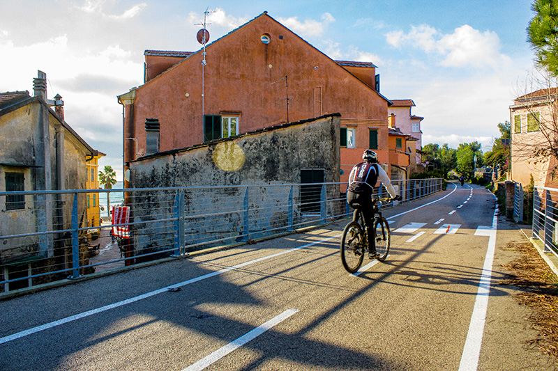
Die erste Abschnitt auf dem Radweg ist San Lorenzo. Im Herzen des Dorfes mit den bunten Häusern der Fischer, das Meer überblickend und von den Bergen geschützt, beginnt unser wundervoller Radweg für fast 24 Kilometer bis er in Ospedaletti endet.

Auf diesem Abschnitt (und allen anderen) können sie entweder zu Fuss gehen oder das Fahrrad nehmen aber ganz egal für was sie sich letztlich entscheiden, es wird eine einzigartige Erfahrung!

Das Mittelmeer mit den brechenden Wellen auf einer und die unberührte Natur auf der anderen Seite lassen eine lebendige Stimmung aufkommen wie sie kein anderer Radweg in Italien bietet.

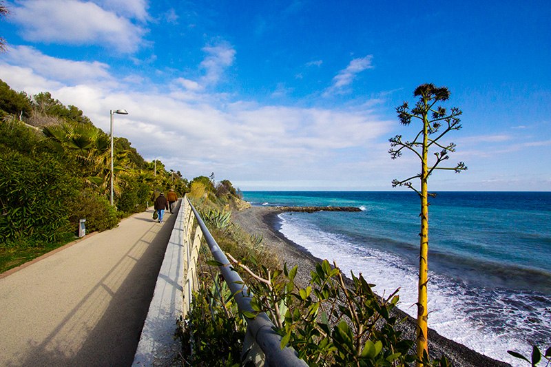
Eine Mischung aus Farben, Gerüchen und Eindrücken sind der ständige Begleiter auf den ersten Metern des Radwegs und viel spannender ist die Tatsache, dass vor einigen Jahren hier noch die Züge diesen, von der Natur vorgegeben, Engpass, befuhren.

Geschützt von den Bergen “Petachin” und „Ciambellin“, hat das Dorf San Lorenzo die Form eines Ankers, dank des gleichnamigen Flusses der hier ins Meer mündet, genau neben dem Herzstück der Stadt, dem Strand von San Lorenzo.


Wie komme ich nach San Lorenzo


Wenn man mit dem Auto anreist, sollte man die Autobahn A10 bei Imperia West verlassen, dann weiter auf die Via Aurelia in Richtung Ventimiglia und nach ein paar Kilometern erreicht man San Lorenzo. Es gibt mehrere gratis Parkmöglichkeiten um den Friedhof herum und kostenpflichtige Plätze in der Stadt, z.B beim alten Bahnhof. Man ist also nur 5 Minuten vom Radweg entfernt, kann beruhigt das Auto abstellen und sich auf einen entspannten Tag auf dem Rad freuen.

Es bietet sich ebenso an die öffentlichen Verkehrsmittel zu benutzten: die Imperia-Sanremo Linie befördert Sie direkt zum Radweg, allerdings können in Bussen keine Räder mitgenommen werden, hier bietet sich an bei der Ankunft in San Lorenzo diese einfach zu mieten.


Streckendetails & Infos für San Lorenzo


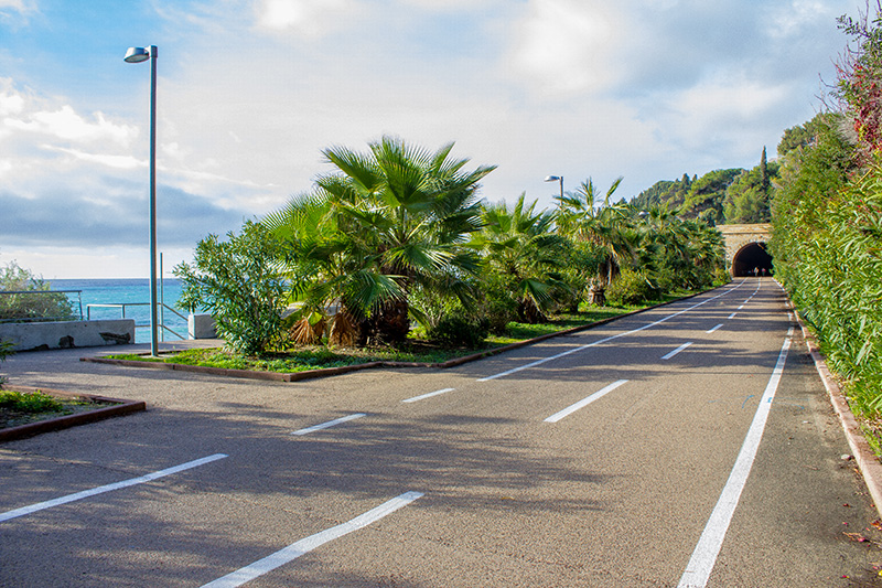
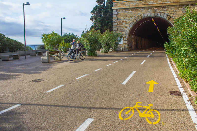
Der erste Abschnitt entlang des Radwegs in San Lorenzo ist einfach und ohne jegliche Schwierigkeiten, abgesehen von einem 1,5km langen Tunnel. Sie können sich sicher sein, dass die Landschaft nach diesem kurzen Stück für alles entschädigt und sich der Aufwand lohnt.


Wenn man dem Radweg entlang der alten Bahnstrecke folgt, sieht man, dass das alte Eisen schon lange nicht mehr da ist und nun alles perfekt mit der Natur im Einklang ist. Ab hier verläuft der Radweg gerade entlang mit der Meerespromenade von wo man sehr leicht zum Strand kommt um etwas zu entspannen.


Nach dem ersten Abschnitt der durch den Tunnel weitergeht, gibt es einen Weg, der Radfahrer die versuchen den Tunnel zu umgehen indem sie am Meer entlangfahren, in die irre führt.

Dieser Pfad endet abrupt. Trotzdem kann man von hier die Bushaltestelle an der Via Aurelia in der nähe  des Costarainera Krankenhauses erreichen um auf der Aurelia entlangzufahren und später wieder auf den Radweg zu gelangen. Diese Option wird nicht empfohlen, da die Strasse sehr stark befahren ist und der Zugang von hier schwierig.


Campeggio “Il PERSIANO” M.W. ***

Campeggio “Il PERSIANO” M.W. ***


Dal 1984 la nostra è una piccola oasi di pace nell’entroterra ligure a due passi dal mare. Il campeggio è immerso in un uliveto con alberi secolari ben tenuti e conservati su un pendio poco scosceso e con terrazze spaziose, situato in una zona salubre, silenziosa, tranquilla e rilassante, a 1.500 m dal mare. La strada provinciale che collega l’Aurelia al campeggio prosegue per il Monte ‘Faudo’, meta di gite e di sentieri per mountain-bike. Situato a pochi km. dai principali centri della Riviera dei Fiori (Imperia, Diano Marina, Sanremo e Ospedaletti, è raggiungibile anche con la Pista ciclabile sul mare). La vicinanza al mare, la tranquillità ed i comforts offerti contribuiscono a fare del Campeggio “IL PERSIANO” il luogo ideale per le vostre vacanze.

Campeggio “Il PERSIANO” M.W. ***
Via Provinciale Civezza, 135
18017– San Lorenzo al Mare (IM)

Per informazioni e prenotazioni:
Tel/Fax 0183.91994

campeggioilpersianomw@virgilio.it
www.campeggioilpersianomw.it

San Lorenzo al Mare

Discover the first town on the bike path


The first stage of the cycle path is San Lorenzo. Right in the village with its colorful houses owned by the fishermen overlooking the sea and protected behind the mountains our wonderful cycling track starts with almost 24 kilometers in total length, finishing in Ospedaletti.
On this leg and all others you can either walk or ride the bicycle but no matter what you will choose it is going to be a unique experience in the end.

The mediterranean sea with its breaking waves on one side together with untouched nature on the other creates a unique vibe unlike any other bike path in Italy.

A variation of colours, scents and sensations will accompany you on those first steps of the bike track to San Lorenzo and what makes it even more fascinating is that at one point this trail was inaccessible because of the railway that ran just along the narrow passage predefined by nature.

Protected by the hills of “Petachin” and “Ciambellin”, the village of San Lorenzo has the shape of an anchor thanks to the river with the same name that eventually empties into the sea right next to the towns core element, the beach of San Lorenzo.


How to get to San Lorenzo


If you decide to get here by car, leave the highway A10 at Imperia West, take the Via Aurelia towards Ventimiglia and after a few kilometers you will arrive at San Lorenzo. There are several free parking sites (area of the cemetery) and others at charge around the towns center (old train station). So just 5 minutes away from the tracks starting visitors can safely leave their car and roll up for a day of relaxation.

You can also comfortably use the public transport: the Imperia-Sanremo line drops you off right at the beginning of the cycle track but be aware that it is not allowed to carry bikes on public buses. Instead you can easily rent one right on your arrival in San Lorenzo.


Track characteristics & details in the heart of San Lorenzo


The first leg along the bike path in San Lorenzo is very simple without any difficulites besides a short tunnel-ride for about 1,5km. To those that might think of this drive as unpleasant, be assured that the landscape afterwards will make up for the effort and leave you speachless.

If you follow the bike path along the old railway track you will see that the shiny iron is long gone and everything now harmonizes perfectly together with nature again.
From here the cycle path follows a straight way lining up with the seaside promenade from where you can easily go down to the beach for a little relaxation time.

After the first leg that continues through the tunnel (equipped with SOS posts and humidity protection) there is a small path that can mislead visitors who try to skip the tunnel by following the ocean.
In fact the trail stops at some point and blocks the passage. However, from this small dirt road you can reach the bus stop alongside Via Aurelia near the Costarainera Hospital (next to the famous shelter known as Sanatorium or former Institute Elioterapicol) for people who want to continue on the Via Aurelia and then later rejoin with the bike path again. Be aware that this is not recommended as the main road is quite frequented and the access road bumpy.

Link d'interesse

San Lorenzo al Mare

Alla scoperta del primo Comune della pista ciclabile

La prima tappa della pista ciclabile è quella di San Lorenzo. Proprio qui, in questo borgo affacciato sul mare, con le case colorate dei pescatori e protetto alle spalle dai monti, nasce la nostra splendida pista ciclabile lunga quasi 24 chilometri totali e che porta fino a Ospedaletti. Potete percorrere questa tappa, come tutte le altre, a piedi o in bici e qualsiasi modo scegliate riceverete in regalo un’emozione unica.

Il mare e il fragore delle onde da una parte, la natura incontaminata dall’altra, vanno a creare insieme una cornice che non si ritrova in nessun’altra pista ciclabile d’Italia.  Una magica alternanza di colori, profumi e sensazioni vi accompagnerà in questo primo tuffo nella pista ciclabile a San Lorenzo e ciò che la rende ancora più affascinante è che, un tempo, questo tratto era inaccessibile a causa della ferrovia che correva con i suoi binari di acciaio proprio nello stretto passaggio concessole dalla natura.

Protetto dalle colline dei “Petachin” e “Ciambellin”, il borgo di San Lorenzo ha la forma di un’ancora e sembra volersi lanciare in acqua grazie anche all’omonimo rio che scorre verso il mare come un’arteria che vuole raggiungere il suo cuore: la spiaggia di San Lorenzo.

Come arrivare a San Lorenzo

Se decidete di arrivare qui in auto, uscendo dall’autostrada A10, Imperia Ovest, percorrete l’Aurelia in direzione Ventimiglia e dopo pochi chilometri arriverete proprio a San Lorenzo. Diversi parcheggi gratuiti (zona del Cimitero) e altri a pagamento proprio nel centro del paese (vecchia stazione ferroviaria) e a soli 5 minuti dall’inizio della pista, facilitano i visitatori che possono lasciare la loro macchina in totale sicurezza e dedicarsi una giornata all’insegna del relax.

Stessa comodità anche se decidete di utilizzare i mezzi pubblici: la linea Imperia-Sanremo vi lascerà proprio nei pressi dell’inizio della pista ciclabile, ma sugli autobus di linea non è permesso trasportare le bici che invece potete comodamente noleggiare proprio una volta giunti a San Lorenzo.

Caratteristiche tecniche della pista nel cuore di San Lorenzo

Questa prima passeggiata lungo la pista ciclabile dentro a San Lorenzo è molto semplice, non presenta difficoltà, ma bisogna percorrere circa un chilometro e mezzo in galleria. Per quanto l’idea di camminare a lungo in un ambiente così possa farvi storcere il naso, il paesaggio all’arrivo vi lascerà senza parole e quei passi appena effettuati saranno completamente dimenticati. La luce al fondo della galleria si intravede già dopo i primi metri e come una calda mano tesa verso di noi ci porta ad affrettarci per godere del panorama mozzafiato che ci sta aspettando.

La tappa numero uno della pista ciclabile comincia così ricalcando il vecchio percorso della ferrovia. I binari lucenti non ci sono più, ora tutto è cambiato e si intreccia perfettamente con lo spettacolo della natura. La pista ciclabile qui segue un percorso rettilineo affiancando il lungomare pedonale da cui, per qualche momento di relax, potrete scendere agevolmente in spiaggia.
Dopo il primo tratto ci imbattiamo così nella galleria (dotata di colonnine di SOS e di tettoie anti umidità) alla cui sinistra si apre un piccolo percorso che trae in inganno i visitatori che pensano di poter raggiungere l’uscita del tunnel passando via mare. In realtà qui il sentiero ad un certo punto si blocca e impedisce il passaggio. Da questa piccola stradina sterrata però potrete raggiungere la fermata dell’autobus lungo l’Aurelia, nei pressi dell’Ospedale di Costarainera ( accanto alla struttura di ricovero più nota come Sanatorio o ex Istituto Elioterapico) e volendo proseguire lungo l’Aurelia per poi scendere nuovamente lungo la pista ciclabile. Questa variabile è sconsigliata perché la strada principale è molto trafficata e la stradina di accesso è dissestata.